


About
Image: https://www.instagram.com/matt.tyrer/
This is a great coastal walk for the fit and healthy, taking in some fine scenery, historical sites and seabirds. It can be done as a circular walk, or if you have two cars then leaving one at either end makes for shorter day.
The walk begins at the car park at Breaclete Community Centre. From here a walk down a single-track road to Valasay and then across a footbridge to adjoin a rough track that contours the western coastline. The path is marked by way markers, following the shore for about two miles, passing through sites of historic interest such as a deserted village and ruins of fish curing buildings. Beautiful views and nature abound, including sightings of otters, Cormorants, Razorbills and other seabirds. Further on the path rises to cross moorland before descending to the Iron Age house at Bosta beach. From Bosta, the walk continues via the single-track road back to Breaclete. If you time it right, you might make it back to the café for tea and cake!
There is a leaflet available to download here or you can collect a copy from Bernera Museum at Breaclete Community Centre during opening hours.
Map & Directions
- Leave the Community Centre and head off west along the road towards Tacleit, crossing the cattle grid and zigzagging along the top of Loch Barabhat until the turn for Bhalasaigh is reached on the right.
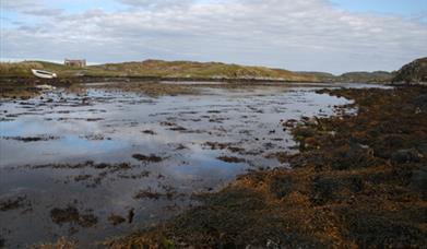
- Continue through the small township of Bhalasaigh to the road end, then cross the footbridge that spans Tòb Bhalasaigh. Turn right at the first house, passing through three gates. Follow the way markers north alongside Loch Veiravat, looking left along the shore of Camas Sanndaig at low tide to see remains of a stone lobster pond.
- Once you reach the road follow it north to Tobson, (NB141384), thought to be the oldest township on Great Bernera, then turn left for 150m before picking up the way markers as they lead you gently up the biggest ascent of the route at Beinn an Toib. The view west to the islands of Pabaigh Mòr and Bhacsaigh with the sweeping sands of Tràigh na Beirgh behind them is spectacular.
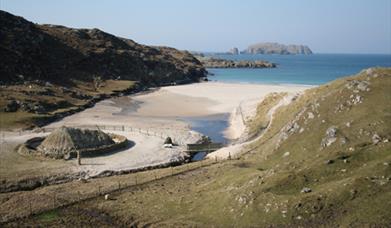
- Continuing on past Carnan Gibegeo and through a gate in a stone wall, the path eventually drops into a small valley and follows the stream that flows north out of Loch a Sgail, "the loch of the squall", to the deserted village of Bostadh. The stream is home to the dipper, a short, stumpy bird that has the remarkable ability to enter fast flowing streams and walk underwater in search of food. But your attention will be drawn to the thatched structure at the back of the beach. In 1993 a severe storm cut away the dunes to leave a series of stone structures projecting through the sand. The archeological department of the University of Edinburgh excavated the site in 1996 and found evidence of a Norse settlement. But underneath the Norse levels was a series of five Pictish ‘jelly baby’ or ‘figure of eight’ houses that were remarkably well preserved despite dating back to the second half of the first millennium, - i.e. some time after 500AD. What you see today is a reconstruction in a spot free of archeological remains; the excavated houses having been reburied for preservation.
- Then wind your way back along the road to the start at Breacleit.
- At the turn for Tobson, there is a cairn erected in 1992 to commemorate the Bernera riot of 1874, when a group of crofters stood up for their rights.


