


About
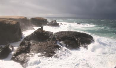
A few years ago the "Guinness Book of Records" claimed that the Butt of Lewis was the windiest spot in the United Kingdom. Other locations make similar claims, but being on the exposed north-west tip of Lewis with persistent battering from the Atlantic winds, this walk around the Butt of Lewis is certainly best left for a calmer and preferably sun-blessed day. Then you are more likely to feel at ease walking along the exposed cliff tops with the sea boiling below – and more willing to bide your time to take in the birdlife and ponder on the prehistory around you. The walk is circular starting and finishing at the playpark is ample parking.
Note this walk is NOT for windy days or vertigo sufferers!
For more information download a leaflet here.
Image: Rachel Keenan
Map & Directions
- The red-brick Butt of Lewis Lighthouse was built by brothers David and Thomas Stevenson in 1862 and remains an important beacon for shipping. Today, the lighthouse acts as the monitoring station for the automatic lights on the Flannan Isles, North Rona and Sula Sgeir and is the radio control station for the North Minch area. The light itself was automated on 30 March 1998 and is now remotely monitored from the Northern Lighthouse Board’s headquarters in Edinburgh. The brothers were members of the third generation of the famous Stevenson family who designed and built 97 lighthouses around the Scottish coastline over a span of 126 years that ended in 1937. Thomas’s son, Robert Louis Stevenson, was a great disappointment to his father in that he chose not to enter the family profession, instead finding fame as the author of classics including ‘Treasure Island’ and ‘Dr. Jekyll and Mr. Hyde’. Start from here and follow the cliffs south west, keeping at a safe distance from the very edge of the cliff top, which is prone to collapse. Stay near enough to enjoy the wheeling birdlife below. Kittiwakes, fulmars and shags nest along these cliffs and there is always something to watch. Further out to sea, gannet will be arching the winds and diving for fish and there is always the prospect of seals, porpoise and possibly a basking shark.
- After a kilometre at the point where the coastline turns due west to a promontory, there is a noticeable flat-topped, grassy rock stack called Luchruban or Pigmy’s Isle, (NB507661) so named because it is alleged to have been inhabited by a race of pigmy people. The small bones found there turned out to be the remains of birds and mammals, which probably formed part of the diet of the early Christian who occupied the stone cell on the summit. This tidal island is a piece of the original cliff which has been separated by the continual erosion of the pounding sea. At low tide, you can descend a scree gulley and climb the rocky wall of the island. The remains of the cell can still be seen, facing north east away from the prevailing wind and back along the riven cliffs towards the Butt. Make sure you keep an eye on the tide and don’t stay too long otherwise you could be experiencing the hermitic life yourself until the next low water in 12 hours time.
- Either circumnavigate the promontory above the natural sea arch of Roinn a’ Roidh - the Eye of the Needle (NB 506 658), which is better seen from much further south, or head due south to Cunndal and then southwest towards the skerries at Sìnntean, (NB 510653), following the marker posts and passing through a couple of gates to reach the relative shelter on the beach of Traigh Shanndaigh.
- When you are ready to continue, head east to the back of the dunes and follow a track that leads up to the township of Eòropaidh, crossing the B8013 twice until at the end of a flower strewn path of buttercups, you arrive at Teampall Mholuaidh, St. Molveg’s Church, (NB 519 652). This tiny church dates from sometime between the 12th and 14th centuries and was once one of the three main centres of Christianity in the Outer Hebrides and is recorded as being a centre for pilgrimage in the 16th century when the sick and infirm came here seeking miraculous cures for their ailments, sores and insanity. The church was extensively restored in 1912 and is still used for a monthly service in all but the coldest months. It is stuck out behind the crofthouses amid the narrow field strips. When it came to apportioning land for crofting, it was not a priority to be generous with space around the chapel and it is tightly confined within a stone wall. Perhaps this was because the chapel stood for the wrong type of religion; perhaps because conditions were such that every available piece of productive land needed to be used. What ever the reason, the chapel now seems strangely out of place as though the community has turned its back on it. However the interior is charming and well worth a visit.
- On returning to the road, turn left along the B8014 to An Cnoc Ard and left on a waymarked track that leads past the twin standing stones of Clach Stein to Dùn Eistean (NB536650). This was the site of a medieval fort and is accessed by crossing a steel footbridge that can be said to span the Altantic. There are the grassed over footings of several buildings that excavation has show to include dwellings, a barn and kiln for drying grain as well as a man-made pond to catch fresh water. A large oval mound at the highest point of the stack has the medieval remains of a fortified stone tower, known as ‘Taigh nan Arm’ (the Armoury) associated with the Clan Morrison and recent finds of musket balls and pistol shot are thought to date back to 1595-96 when they were besieged by the MacKenzies.
- To return to the lighthouse, head north along the back of the crofts, perhaps stopping off at the beach at Port Stoth and a paddle to refresh tired feet.
")


