

Wayfinder
Bernera
Grade
ModerateType
WalkDescription
A stunning circular walk in Great Bernera, including a visit to the Iron Age village remains and Iron Age house reconstruction at Bostadh / Bosta beach. The route starts at the community centre (with museum and cafe) at Breacleit / Breaclete, where you can park, and follows along to the road end in Bhalasigh / Valasay. Once over the footbridge the route is waymarked until eventually you arrive at the village of Tobson. From Tobson the route continues to be waymarked up Beinn an Toib and then down to the reconstructed Iron Age house at Bostadh. From Bostadh, the route continues along the road back to the start at Breacleit.
Walk Waypoints
- 1 Leave the Community Centre and head off west along the road towards Tacleit, crossing the cattle grid and zigzagging along the top of Loch Barabhat until the turn for Bhalasaigh is reached on the right.
-
2
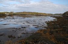
Continue through the small township of Bhalasaigh to the road end, then cross the footbridge that spans Tòb Bhalasaigh. Turn right at the first house, passing through three gates. Follow the way markers north alongside Loch Veiravat, looking left along the shore of Camas Sanndaig at low tide to see remains of a stone lobster pond.
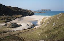
- 3 Once you reach the road follow it north to Tobson, (NB141384), thought to be the oldest township on Great Bernera, then turn left for 150m before picking up the way markers as they lead you gently up the biggest ascent of the route at Beinn an Toib. The view west to the islands of Pabaigh Mòr and Bhacsaigh with the sweeping sands of Tràigh na Beirgh behind them is spectacular.
-
4
Continuing on past Carnan Gibegeo and through a gate in a stone wall, the path eventually drops into a small valley and follows the stream that flows north out of Loch a Sgail, "the loch of the squall", to the deserted village of Bostadh. The stream is home to the dipper, a short, stumpy bird that has the remarkable ability to enter fast flowing streams and walk underwater in search of food. But your attention will be drawn to the thatched structure at the back of the beach. In 1993 a severe storm cut away the dunes to leave a series of stone structures projecting through the sand. The archeological department of the University of Edinburgh excavated the site in 1996 and found evidence of a Norse settlement. But underneath the Norse levels was a series of five Pictish ‘jelly baby’ or ‘figure of eight’ houses that were remarkably well preserved despite dating back to the second half of the first millennium, - i.e. some time after 500AD. What you see today is a reconstruction in a spot free of archeological remains; the excavated houses having been reburied for preservation.
- 5 Then wind your way back along the road to the start at Breacleit.
- 6 At the turn for Tobson, there is a cairn erected in 1992 to commemorate the Bernera riot of 1874, when a group of crofters stood up for their rights.


