Wayfinder
Northton
Grade
EasyType
WalkDescription
Walk Waypoints
-
1
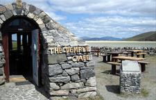
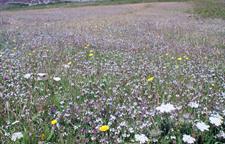
Park in Northton and walk north-west to the end of the road then carry straight on along the track for 800m to a gate where paths go off in different directions. These pastures are part of the machair, a low-level coastal plain that runs along much of the Atlantic coast of the Outer Hebrides. It is formed by the wind blowing fine sand that is high in shell content onto the boggier acidic grasslands. This results in a rich fertile pasture able to support livestock and a multitude of wild flowers which clothe the ground during late spring and early summer. The gate that leads out onto the machair has an arrow pointing left to indicate the track that leads to the Teampall.
-
2
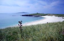
Follow this track as it heads west through the dunes and behind a series of small sandy bays. You will soon catch sight of the Teampall sticking out on the headland.
-
3
Return by the same route