
Wayfinder
Coffin route
Grade
ModerateType
WalkDescription
Coffin Route
Walk Waypoints
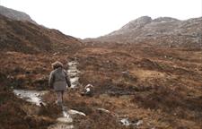
- 1 The start of the Coffin Route is marked by a sign at the T junction at the head of Loch Stocinis (NG127929) where there is good parking.
- 2 Turn left behind Cnoc Biorach. The first half of the route is way-marked with poles and these will take you left below Cnoc Biorach (NG122938) and past the house at Ceann a’ Bhaigh Mhòr (NG116932
-
3
The first half of the route is way-marked with poles and these will take you left below Cnoc Biorach (NG122938) and past the house at Ceann a’ Bhaigh Mhòr (NG116932). Follow the signs turning north west and heading directly for Bealach Eòrabhat (NG100947). Although much improved this stretch of the path can still be wet. To the south of Bealach Eòrabhat is Creag an Eoin which means the rock of the bird and you may be lucky enough to see one – an eagle.
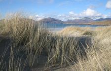
- 4 Just before the path descends to the west, there are two benches where you can stop and enjoy the view across Tràigh Losgaintir to Taransay. The graveled track to Loch Carran (NG086960) is mercifully dry and the ground is covered quickly. Those who remember their school geography will recognize the ‘drumlins en echelon’ just below the loch.
-
5
At this point the route turns right and follows the old coast road north to the current main road.
- 6 Follow the main road eastwards to where it crosses Abhainn Lacasdal (NG112968).
- 7 Here we make use of the old road again and follow it south east past the cottages at Loch Lacasdail (NG108963) and uphill beneath Creag Ghlas (NG119952). Shortly after passing a mast which is as yet unmarked on both series of OS map, the route goes through a working quarry and you should read the instructions set out on the danger signs and, if the siren can be heard, wait until the all clear is given before proceeding.
- 8 Once on the main A859 road, continue south east towards the junction signposted for Geocrab (NG115944), making use of the old road as a short-cut at the junction. The babbling of the Abhainn Lackalee makes a pleasant accompaniment for the 2km walk along the road back to the start. Look out for numerous stone walls and piers that have been built into the river along the way, thought to be for controlling the flow that worked a mill that once stood at the bottom of the hill.

